Showing posts with label Nature and Outdoors. Show all posts

Goa Gajah Temple


Welcome to Gua Gajah (Elephant Cave) which is located in west side of Bedulu countryside, Blah Batuh Sub district and Gianyar Regency. It is about 27 km from Denpasar town. This cave is built at crevasse edge from the federation of 2 rills that is called Pangkung River , where the irrigation is mixed with Petanu River flow. The federation area of two rivers is called Campuhan/Mixture. It owns the magical energy on the basis of Rwabineda Concept/two different matters on this basic concept hence Gua Gajah (Elephant Cave) is intentionally built among two rivers.

The word of Gua Gajah is anticipated coming from the word of Lwa Gajah, the name of Buddhist Temple or hermitage for Buddhist monk. The Gua Gajah's name is written on Negarakeertagama papyrus which is compiled by Mpu Prapanca on 1365 M. Lwa or Lwah/loh mean the river and it reflect to the meaning that the hermitage is located at Gajah River or in Air Gajah. In the year inscription 944 Saka, it is mentioned with the name of ‘ser ring Air Gajah' that is meaning the Subak leader in Air Gajah. The word has mentioned that the hermitage of Lwa Gajah is located in Subak Air Gajah.  


There is a relief which is almost looking like the form of mountain on the entrance of this cave. It was carved many designed on the relief like grove with the stick, close leaf, animal for example forest pig, tortoise and specters. The cave mouth is decorated by the bas-relief with the eye turn around to the right or west side. There is an article letter of Kediri type from the early of 11 century was written on the wall  left side or east side. There is a pool (Patirthaan) as a place to take the holy Tirtha water for Hindu ceremony which is located in the middle of the cave courtyard. This Holy Pool is previously piled up by land and it has been found on 1954 by Krijgsman from the Ancient Department. The Holy pool is equipped by the statue douche which is parallel arranged in two groups.

Since it is appointed as tourist destination, Gua Gajah is many visited by tourist everyday due to it is strategically located on the main road Ubud – Kintamani. Kintamani Volcano Tour is one of the famous land tour in Bali usually put this tourist destination on the tour itinerary. It was well completed by public facilities like toilet, parking area and souvenir shops available.

Ubud Village

 Ubud Village is a traditional village supervising 13 Banjar (group of community) and 6 custom countryside. It is located in Ubud sub district, Gianyar Regency  and about 20 km from Denpasar Town. Ubud Vilage can be reached within 30 minutes or 15 minutes from Gianyar Town and this place is situated in the high land about 300 meter above sea level. Ubud is surrounded by the good temperature compare with other regions in Bali where the temperatures are relative cool that is ideally for everyone to stay in this beautiful place. This village is occupied 9.800 peoples which most of them are Hindu. They able to keep the environment naturally so that way this place usually used by many tourist/people/actors to get the art inspiration.

Ubud Village is also well known as a culture village where we easily find the local community presenting traditional cultures from the ritual up to the traditional dance performances. This village own the rich culture with the history heritage of all big actors, especially all famous artists, for example I Gusti Nyoman Lempad (1862 - 1978), Anak Agng Gede Sobrat (1919 - 1992), I Gusti Made Deblog (1910 - 1968), afterward caught up by others like, I Gusti Ketut Kobot, Ida Bagus Made, Dewa Putu Bedil, Ida Bagus Rai and others. The popularity of all above artists follows to give the inspiration to all west artists to live in Ubud Bali. In year 1920's, two European artist people that are Rodolf Bonnet from Dutch and Walter Spies from Germany inscribe the new history of artistic growth paint the countryside of Ubud. Second, the European artist introduce the European esthetics technique especially illumination area, shadow, perspective and anatomy. All local artists permeate the new technique matching with value and base on local mind fixed take the traditional so that able to give the separate identity by the name Ubud. Ubud Village progressively famous as a born area of all painters because the existence of the cooperation between Tjokorda Gede Agung Sukawati and Rudolf Bonnet to form the Pita Maha. Pita Maha represent a place to discuss the artistic growth and problem paint, and also to compare mind to each other and introducing result of art which they own.  


Ubud Village Tour is an exciting tour package to visit places interest in this village and surrounding area. There are other Ubud Tour Package available which all of them visit this village like Elephant  Ubud Tour, Rafting Ubud Tour , Elephant Safari Ubud Tour and Ayung Rafting Ubud Tour .

Ubud is one of tourist places in Bali provides many hotels from luxury until the low budget. We can recommend the following hotels in Ubud which you can select one of them based on your budget:

  • Maya Ubud Resort
  • Cendana Resort
  • Ubud Village
  • Agung Raka Bungalow
  • Villa Semana
  • Natura Resort
  • Barong Resort
  • Ibah Hotel
  • Pita Maha
  • Royal Pita Maha
  • Kupu - Kupu Barong
  • Kra-Chaai Villa
  • Begawan Giri
  • Komaneka Tanggayuda
  • Komaneka Resort
  • Alila Ubud
  • Ubud Village
  • Alam Puri Villa
  • Teba House

Ubud Traditional Art Market

 Ubud Traditional Art Market where the existence is not far different from other markets available in the tourism area. This market as a society economics center of Ubud and it is apposite to the existence of Ubud Empire that is called Puri Saren. The market is unfolding from west to easterly divided become two group with different purpose. There are two markets available at the same area those are one block at the Westside is for a traditional artistic market  and another block located in the east as an everyday traditional fundamental market requirement. This market is opened every day about at 08:00 until 18:00, even some from them still open until nighttime. While the traditional market for the fundamental requirement is opened everyday at 06:00 - even before that there is morning market started at 04:00 morning.

The art crafting are sold in this art market consisted of various crafting, from traditional until contemporary crafting which its price is relatively cheap. You can do the transaction directly to the merchant which generally can be bargained. All the crafting sold in this place you can bring home as souvenir like slipper, wood idol, bag, clothes, matting, painting and a lot of more. 


It is very simple way and easily to find Ubud Market since it is very famous among the Balinese and it is strategically located in the center of Ubud Village. This market is located just in the front of Ubud Palace with crowded of visitor who purchases the items every day. This market is close to other places of interest in Ubud like Ubud Palace, Ubud Monkey Forest , Tegalalang Rice Terrace, Painting Museum and Gua Gajah. You can also join the Ubud Tour Package or other tour arrangements like Elephant Ubud Tour, Rafting  Ubud Tour , Elephant Safari Ubud Tour and Ayung Rafting Ubud Tour

Ubud Monkey Forest

Ubud Monkey Forest is a small rain forest dwelt by some group of monkeys and other tropical animals. It is strategically located in the hearth of Ubud Village, precisely located in the region of Padang Tegal Village, Ubud Sub district and Gianyar Regency. Monkey Forests in Balinese language called Wanara Wana are spread out in the island and Ubud Monkey Forest itself own very important function of the continuity the monkey habitat in Bali. Meanwhile the local community own important role to keep this forest naturally in order to all wild animals able to live smoothly.

Ubud Monkey Forest is dwelt by 200 monkeys, pertained to long tail inclusive macaques or macaca fascicularis group which owns the wide disseminating area. Among the amount monkeys living in this forest, there are 23 adult male, 79 adult female and 98 still baby. All the monkeys in this forest consisted of three groups, dwell certain area and use the certain place and certain time. However, it also happened that entire group can use the forest and whenever two groups are existing at same place and time, they will fight each other. These monkeys are believed as Gods Guard of Dalem Agung Temple, The Hindu Temple exist in the middle of forest. There are three Holy Temples in this monkey forest and those are existing surround the forest and it is estimated built in the middle of 14 century, in the early governance of Gelgel dynasty. Dalem Agung Temple is located in northwest from the forest represent the existence of most important temples. Beside of two others, that are Permandian Temple, in Westside from this forest and Prajapati Temple which is located in south-east side where the place of Dewa Siwa (Siwa God), one of the Khayangan Temple in Padang Tegal Village.  


It is very easy to find this place since it is located in the hearth of Ubud Village and it is just about 1 hour drive from Denpasar Town. This monkey forest is close to other places of interest in Ubud like Ubud Palace, Ubud Art Market, Tegalalang Rice Terrace, Painting Museum and Gua Gajah. You can also join the Ubud Tour Package or other tour arrangements like Elephant  Ubud Tour, Rafting Ubud Tour , Elephant Safari Ubud Tour and Ayung Rafting Ubud Tour .

Tampak Siring Temple


 Tirta Empul Temple or Tampak Siring Temple is a holy spring water temple located in Tampak Siring Village, Gianyar regency and it is about 39 km eastwards from Denpasar town. It is set in the dale and encircled by the hill. In the west side of this temple, there is an Indonesian President palace which has been found by the first president. The name of Tirta Empul is loaded in a inscription which is kept at Sakenan Temple, Manukaya village, Sub district of Tampak Siring, about 3 km from Tirta Empul Temple. In this inscription, the Tirta Empul is named by the Tirta Ri Air Hampul and then the name has changed into Tirta Hampul and finally become the Tirta Empul. Tirta Ri air hampul is meaning the water emerge or the holy pool (Petirthan) which is the water emerge from the land.

The wellspring emerges from the land is believed that it is the infinite creation. According to the history, that, that this water source is arranged and sanctified by king Indrajayasinghawarmadewa in the year 882 Saka (960 M). He has given the name with Tirta ri air hampul. The data is loaded in the inscription that is located at Sakenan Temple. Besides of the above epigraphy data, in Tirta Empul Temple is also found the archaeology omission like Colossus Yoni, Arca Lion, Tepasana and Tirta Empul Pool. According to papyrus of Usana Bali narrated that Tirta Empul is created by Bhatara Indra (Sun Deity) when bearing arms against the king where his palace is located in Bedahulu Countryside. He is known as a very miraculous king, which he can lose or show suddenly, therefore he is named by Mayadenawa. Because of its miracle, he becomes the arrogance and expressing himself as a god. The Mayadenawa King owns the assistant (Patih) which is called Kalawong. They prohibit the people to do the Yadnya (praying to the god) so that is often happened the natural disaster, disease epidemic, agriculture fail and finally miserable life society. Finally Betara Indra (one of Hindu God) gives battle against the kings that happened in Tampak Siring and then the Mayadenawa is gone to the wall and disappear. King Mayadenawa has also created poisonous pools which can the team of Bathara Indra die and faint after drinking this water. Then Bathara Indra stick the weapon of Umbul-umbul and finally the water is emerging so that called by Tirta Empul and then it is passed to the dead and faint soldier that made them back to live. Therefore at the moment this pool water is sanctified by the Hindu society in Bali and they believe that this water source can heal various of diseases, hence every day this place is a lot of visited by Hindu people to do the ritual and sanctify them self . This place has been opened for public and as a famous tourist destination  in Bali.

Kawi Mountain

 Gunung Kawi is a Hindu Temple  complex with old omission from the stone era located in Gianyar regency. Based on the inscription of Tengkulak A on 945 saka (Balinese calendar) which is released by Marakata King, the ancient omission complex is located at the Pekerisan River then it is called Katyangan Amarawati. Pekerisan River is also named by Jalu which is according to the inscription chiseled on the above of the biggest temple door sound ‘Haji Lumahing Jalu'. The name of Gunung Kawi is the name given on the omission which is related to the complex of temples because the temple on this area is like the symbol from the mount. There are 3 temples which so called the name as Gunung Kawi in Bali  those are Gunung Kawi in Sebatu countryside, Gunung Kawi Temple in Keliki countryside and Gunung Kawi Temple in Babitra countryside. The ancient omission complex of Gunung Kawi is founded on 10 century. It is founded in the era of Udayana about 989 M. At the period of Marakata governance on 1023, the omission which is called Katyagan Amarawati is developed and continued by the governance of Anak Wungsu which is guess lead between the years of 1049 - 1077 M. 


Consisted of 2 types Temple:

  • Temple Complex.
    Temple complex is consisted of 2 consecutions. The consecution in eastside Pekerisan River is consisted of 5 units and the consecution at west side of river is 5 units, in the north is 4 units and 1 unit is located far in south side separate from the others. On the above of the temple consecution in particular to the Eastside River, there is an article of Kediri word type sounding ‘Haji Lumahing Jalu'. Haji means a king, the Lumah means a temple or Sidha Dewata means to return to the nature of deity and Ing Jalu means in Pekerisan. The Jalu mean the Keris literal. The entire words mean that king is made in temple form at Pekerisan. From this article is assumed that this temple is dedicated to Udayana King which is also called Marakata and Anak Wungsu. The temple which is located in the west side of river related to all king concubines. The temples are located far in the south side is attributed to prime minister because in these temple areas existing an article Rakyan which is namely perform for high functionary of empire.
  • Buddhist Temple Complex
    Buddhist Temple Complex is used as a residence and as place for meditation. It is consisted of some nooks and it is located in the cross east of Pakerisan River. Other nooks are located spread out and near the temple bunch.

Gunung Kawi is a famous tourist destination in Bali with its ancient omission so that this place is the right to visit during your vacation in the island.

Bedugul Botanical Garden


 Bedugul Botanical Garden or Kebun Raya Eka Karya is the huge tropical garden located in Bedugul, plateau area in Bali. It is situated in the cool atmosphere with rain forest and hill surrounds it. This botanical garden is opened on 1959 and owns 154,5 ha land located Tabanan regency, northwest part of Bali. It is close to the beautiful lake which is called Beratan Lake and Ulun Danu Temple. It is completed by more than 1187 plant types and multifarious of floras. In this area, there is orchid garden with the collection of 320 orchid types from Bali, Java, Nusa Tenggara Timur, Sulawesi and also Irian Jaya. We can also meet the rose garden with the collection of various rose from rust colored until green chromatic.

Bedugul Botanical Garden or Kebun Raya Eka Karya is also completed by 524 birches which are still in its original forest. In this place we can meet the collection from America, South America, China, Japan, Australia, Africa and also Netherlands. Cyathea Garden is one of the specific gardens owning the various collections of Paku-pakuan (tropical vegetable) which can be eaten as vegetable by Balinese and some of them are used for decoration. The tree from this nail Cyatheas are often exploited as growth media of various orchid types. Cactus collections are consisted of 104 types. This cactus is obtained from Africa, America, Germany, Switzerland and also Indonesia. The crop season at botanical garden is taken 94 types plants that are the collection from the exploitation for Balinese life ceremony, temple ceremony, devoting / offering and others purpose. It also owns the collection of drug crop with 84 types / species. 


Beside of the crop collections, Bedugul Botanical Garden or Kebun Raya Eka Karya also owns the traditional Balinese houses and it function as guest house for scientist who is doing observation. It is also opened for public including tourists and to be one of favorite tourist destinations in Bali especially for domestic tourists. The most crowded visitors at this place are on Lebaran Period (Moslem holiday), Balinese Holidays, National Holidays and New Year period.

Jatiluwih Rice Terrace

 Jatiluwih is a favorite tourist destination in Bali famous with the beautiful rice terrace unfolding from the foot of mountain until the coastal side. It is one of places to visit in Bali with the beautiful view as according to its name from Jati and luwih, where Jati mean really and Luwih meaning especial, good, and beautiful or the equivalent. The local paddies are planted in this place look typically of the high relative size plant if it is compared with other pre-eminent paddy planted by most farmers in Bali  . Despitefully, Jatiluwih also famous with its organic agriculture system due to the location is located in the in the plateau of Watukaru Mount which is suitable for the agriculture development.

Jatiluwih is surrounded by cool atmosphere because it is located in the height of 700 meters above sea level. Besides its nature potency, Jatiluwih is also saving the cultural potency, especially history of the Petali Temple existence that is related to the power of Ida Dalem Waturenggong King in Keraton Gelgel (1460 - 1552). The distance from Denpasar to Jatiluwih is about 48 km and it is situated in upstate of Tabanan town (28 Km). The road to this place has been progressively improved so that motor vehicle can enter from east side through Pacung Village and go to Jatiluwih and also from the west side from Watukaru Temple pass to Jatiluwih. Jatiluwih is many visited by tourist from local and foreign countries who want to enjoy the cold atmosphere and beautiful panorama of rice terrace. Jatiluwih as a nature tourist destination in Bali which has been recognized since Dutch colonial build the Security Headquarter and until now the local residents conceives with the Dutch Tangs. Indonesian government has assigned the Jatiluwih to be a Tourist Destination Village because of this potency. 

Jatiluwih also keep the unique religious  ceremony attraction  which is famous know as Patirtaan in Petali Temple on Wednesday Kliwon Ugu (Based on Balinese Calendar). The local residents believe that Petali Temple is a worship center of The Hyang Widhi Wasa (the God) as agriculture power. Beside of Petali Temple , there is also Pucak Rsi Temple is located in this area. As a tourist object, Jatiluwih provides the public facilities like parking area, toilet, resting bale and Wantilan for tourist who is enjoying the beautiful panorama. Some restaurants have been built to serve the food and beverage. Watukaru Tour is an exciting tour to visit Watukaru Temple and other tourist destinations like Jatiluwih.

Tabanan Hot Water


Tabanan Hot Water is one of tourist destinations  in Tabanan regency, west part of Bali. it is about 15 minutes from Tabanan town and close to Batukaru Temple. It is set on the hill bank and the river valley just in front of it. There is a main pool located in the lowest level and just beside of river meanwhile other small pools are set on the bank. This hot water is come from the Batukaru mount and flows to the hill bank at Penatahan village, the location of Tabanan Hot Water.

It is located in Penatahan Village, Penebel Sub district and Tabanan Regency. It is about 1,5 hour drive from Bali's International Airport taking the simple direction to go to Tabanan Town and access to Batukaru Temple. It is strategically located beside of main road from Tabanan town to Batukaru Temple.

Tabanan Hot Water is a potential place as tourist destination in Bali  due to the place is unique with original hot water located in the river bank. We can find a hotel, restaurant and small spa in this hot water that completing this area a tourist destination in Tabanan Regency. It is many visited by local and foreign tourists  who want to take a bath in the hot water while enjoy the natural nature surround it.

TELAGA WARNA (the Colorful Lake)

Dieng has an extraordinary natural and cultural wealth. One of the icons is Telaga Warna (the Colorful Lake), a beautiful lake with natural forest around it.
TELAGA WARNA
Desa Dieng Wetan, Kecamatan Kejajar, Kabupaten Wonosobo


TELAGA WARNA (the Colorful Lake)

Beautiful Twin Lakes

 Hidden among the rows of hills at an altitude of more than 2000 meters above sea level does not make Telaga Warna (the Colorful Lake) lack of visitors. Its beauty and mystery always attract anyone who visits Dieng. Entering through the main gate, YogYES was greeted by a path that has been slicked up by the paving blocks with dense forest on either side. Culminate in a T-junction, Color Lake outspread ahead. Greenish water looked calm, no ripples at all. The sound of the wild birds chirped and the thick forest which is wild maintained present a reassuring atmosphere of peace.

Followed a road that branched off to the right, YogYES found another intersection. Paving road towards Semar Cave and a muddy trail. Driven by a curiosity, we took a dirt road trail straight ahead. Jumped on the slippery ground formed by the rain on the previous night, we fought hard to avoid the mudded ground. And suddenly a broad meadow emerged, reminiscent to the movie Little House on the Prairie. Although we were a little in doubt, we kept on walking. Voila, suddenly another lake appeared in front of us. The water was very clear that reflected whatever image was on top of it. Well, it felt like in a different place. Paving road was somewhere out there, meadow was on the other side, and tall trees were all around.

Although we were fascinated by the beauty of this crystal clear lake, but the desire to explore Telaga Warna finally brought YogYES back to the first lake. This time the exploration carried out by following the road that leads to the left. In some places the surface seemed bubbly and pulled out the small bubbles. It caused by the sulfur that contained in the water. Unfortunately, as far as we could see, the entire surface was remained green without a touch of other colors.

Apparently there is a trick to enjoy the beauty of this lake. At the back door, there is a trail uphill towards one of the hills that enclose the lake. This dirt road is very narrow, just enough to pass one person. The climb is not so steep, but slippery enough considering Dieng area frequently hit by rain. After a few hundred meters climbing, we reached the top of the hill which surrounded by the views that would make anyone spellbound. Down below, outspread a beautiful lake surrounded by thick forest with beautiful purple color of water on the edge, shaded in green in towards the middle, and pale green in the center of the lake. On the other side, a narrow meadow separated it from another lake called Telaga Pengilon or lake which reflected like a mirror. Further ahead, Mountain Prau and Mountain Pakuwaja rows in circle, formed as if to protect these two beautiful lakes from anyone who wants to damage it.

Copyright © 2010 YogYES.COM

Opening Hours
Monday to Sunday: 06.00 a.m. to 18.00 p.m.

Ticketing
Domestict visitor: IDR 5,000
Foreign visitor: IDR 9,000


BENGAWAN SOLO

Bengawan Solo, as the longest river in Java is very special, even its history is longer than its length of river. Long time ago, this river was the life vessels of most of the Java Island's dwellers, even once as the landing place of an iron bird.


BENGAWAN SOLO

Cruising the Longest River in Java

The adventure began when the sun was still sleeping on the back of the horizon. While waiting for the boat, we sat on the river bank watching the people starting their activities. The boat crossing route, Kampung Sewu-Bekonang, where we would start the exploration started to be crowded. A large wood boat back and forth transported the merchants who want to go to the market and the dwellers who want to visit the neighbor villages. A small wood boat moved closer to the harbor slowly. Wow, it was the boat that would take us to explore the river that shaped four million years ago. Just a little move will shake the boat. But after couple of paddles, the feeling became more relax. Paddling in harmonizing rhythms took this boat parting the river water and sliding smoothly over the calm flow. The light from the sun cracks the dawn.

About hundred meters away, the river started crowded with the dwellers doing their morning activities. The politeness of friendly local people could be felt immediately. Some of them were watering their crops on the field on the river bank, tending their goats or ducks, or even gathering on a dike talking and joking each other. Long time ago, Bengawan Solo was famous as the fresh water fish heaven. Even there were 30 kinds of fish living and proliferating in this river. However, there are only some of them still surviving such as Jambal, Gabus and Putihan today.


A Ferocious Monster Saves a Garuda Bird

 Under its calm water ripples, Bengawan Solo lays down powerful forces. In the rainy season, the water level increases rapidly, so it overflows to the settlements. The deterioration in the upstream area makes the water from the rain pours down directly into the river and causes shallow and overflow Gajah Mungkur reservoir. If the reservoir overflows, the areas in the downstream such as Solo, Ngawi, Gresik, Bojonegoro and Lamongan will be flooded.

However, the high water is not always causing disaster. YogYES remembers back to the year 2002. It was on January, the peak of rain season. The water level of Bengawan Solo was extremely high. Garuda plane with the flight number 421 from Ampenan to Yogyakarta almost arrived in the destination, Adisutjipto airport. Passing the dark clouds, suddenly both of the plane engines died. The pilot had no choice instead to make a sudden decision, do an emergency landing. The pilot saw Bengawan Solo vessels, so he pointed the plane there and making an emergency landing on the river surface. The depth of the river and the high water level saved all 54 passengers.

We didn't realize that the sun has risen high. The distance of Kampung Sewu-Juruq that usually took 5 minutes by motor or car, took one and a half hour by boat. After stopping for a while under Juruq Bridge for a rest, we came back to Kampung Sewu. Apparently, this trip was harder because we had to paddle against the current. It was a long and exhausting trip, but the experience that we got was extraordinary. In fact, Bengawan Solo is still the life vessel of most of the dwellers. Fishing, planting near the river and tending livestock become their regular activities. Not to mention the ferocious, this legendary river can’t be separated from the dwellers living along its currents.

Copyright © 2010 YogYES.COM


TAWANGMANGU

Tawangmangu offers natural beauty and the cool air on the slopes of Mount Lawu. Enjoying the beauty of rice fields, misty mornings or taste the legendary sate kelinci will make you want to go back again and again.
TAWANGMANGU
Kecamatan Tawangmangu, Kabupaten Karanganyar


TAWANGMANGU

Enjoying Grojogan Sewu on the Slopes of Mount Lawu

 Although it is located at the equator with hot and humid air temperature, Indonesia is endowed with many mountains offering chilly and cool weather. One of them is Tawangmangu, approximately 37 km east of Solo. Although situated on the slopes of mountain, this area is one of the attractions with a very good public transportation access. If you go by bus, it would take approximately 1.5 hours from Solo to get there with beautiful scenery of green rice fields on the left and right of the street.

Tawangmangu in the morning is very beautiful and exotic. The fog and cold air of the mountains beautify the morning. Walking down enjoying beautiful green rice fields, seeing the morning activities of residents, or exploring the traditional market is worth to try, refreshing your mind from daily routines. Tawangmangu is also popular with vegetables and fresh fruits. Fields planted with cabbage, carrots, radishes, strawberries, and various others stretches everywhere.

YogYES also went to an 81-meter-high waterfall located in the region. Grojogan Sewu, means "a thousand waterfalls", is located within a 20 ha protected forest area. This area is also equipped with flying fox, rafting, playground with its fishing area, and the outbound arena with its traffic park and tree train. Not only humans, thousands of monkeys also love this place. They roam freely without fear in humans. Although they seem tame, but you must remain vigilant because they could suddenly take your bag or other stuff.

Foods stalls are scattered around the waterfall, being a place to relax and enjoy the fresh air under the shady trees. The most famous food here is sate kelinci or rabbit satay. Rabbit meat is a little tough but has soft meat fibers, combined with peanut sauce, sliced peppers and onions, served with rice or lontong. According to the experts, in addition to low-cholesterol rabbit meat also has many health benefits. The meat contains substances called kitotefin. These compounds combined with other compounds such as omega 3 and 9 is allegedly able to cure asthma. Based on the experiences of some people, the meat also helps lowering the sugar levels for people with diabetes, while its brain as a fertilizer efficacious of female womb.

Copyright © 2010 YogYES.COM

Opening Hours
Monday to Sunday: 08.00 a.m. to 04.00 p.m.

Ticketing
Domestic visitor: IDR 18,000
Foreign visitor: IDR 18,000
Student: IDR 9,000


KALIADEM

KALIADEM

View all
Address: Sleman, Yogyakarta, Indonesia
GPS Coordinate: S7°38'24" E110°23'13.2"

Kaliadem is the right place where we can look at the beauty of Mount Merapi and also the trace of the 2006's horrible eruption.

KALIADEM - Taking a Closer Look at the Real Face of Mount Merapi

 People said that the best time to enjoy the beauty of Mount Merapi is in the morning, before the fog comes down and hide this mountain from our view. It's 7 am and we were already on our way to go to Kaliadem, a chilly and cold area on the Mount Merapi slope, 25 km north of Yogyakarta. We chose the alternative road through Maguwo because this route has more beautiful rice field view than the Kaliurang street. We were just couples of kilometers away from the city and we already saw the beautiful rice field view that looks like Mooi Indie paintings. The fresh weather got into the car through the open windows and we could breath the smell of the paddy straws, just like the smell of grass right after showered by rain.

It was still morning when YogYES got into Kaliadem. Some of the villagers started to get ready to go looking for grass to feed their livestock. Mount Merapi looks so strong and gallant even though we could see a tiny layer of fog around the mountain. He is standing still on his throne, 2980 meters above the sea level, looks shining because of the morning sunrise. There was a thin smoke comes out from the top of the mountaing, made Mount Merapi looks more beautiful. Ladies and Gentlemen, we proudly present Mount Merapi, one of the most active volcanos in Indonesia!

Strong Power

 ome of the scientists said that it was probably the Mount Merapi eruption that made the Ancient Mataram Kingdom moved into East Java on the 10th century. When it erupted, hot clouds of 800-1000 degrees Centigrade would slide down at speeds up to 70 km / hr. In 1930, the hot clouds from Mount Merapi's eruption destroyed forests, 13 villages, and 1400 people in an instant.

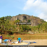
The last eruption was in 2006 when millions cubic of volcanic materials spilled out to Gendol River and Krasak River. Few of them flowed in Kaliadem and the leaving trace of them still can be seen until now. Kaliadem was a pine forest, but now it is full of sands, rocks, and other volcanic materials. There's a building that used to be a food stall on the east side of Kaliadem, but it is half building buried by volcanic materials now. On the west side, there's a protection bunker that is ironically covered by 3 meters thick volcanic materials. The 2006 eruption also killed 2 people who were trying to hide in the protection bunker. It needed weeks for the materials to get cold so that people can come to Kaliadem again.

But like the other natural powers, the Mount Merapi eruption also has positive sides. The volcanic dusts created a fertile land and field around the mountain. Million cubic of sands created jobs for sand miners from surrounding villages. Now after 4 years, Kaliadem starts being green and cold again. The pine trees start to grow and Kaliadem back to be a place where people can look at the beauty of Mount Merapi and also be witnesses of the both sides of a natural power

Mbah Maridjan, The Gatekeeper of Mount Merapi

 After visiting Kaliadem, YogYES stopped by at Mbah (wise old man or grandfather) Maridjan's house at the south of Kaliadem. Mbah Maridjan is a royal servant, born at 1927, and was given an order by the King of Yogyakarta Palace to be the Mount Merapi's gatekeeper, continuing his father job.

As a gatekeeper, he has to "take care" the mountain. Every year he has to lead the ritual of Labuhan Merapi, a ritual when hundreds of people climb up to the near of the Mount Merapi's peak and then pray to the God to protect them. This ritual is held every Rajab month in the Javanese calendar.

Before the 2006 eruption, Mbah Maridjan is very popular among the Indonesian people, especially who live in Yogyakarta. In the beginning May, Mount Merapi starts to spill the lava and the scientist estimated that it's going to explode soon. The people live around Mount Merapi were started to be evacuated, but Mbah Maridjan refused to leave. He said that he was ordered by the Yogyakarta King to take care of Mount Merapi so he did not want to leave because he had to do his job. Couple days after that, Mbah Maridjan climbed up the Mount Merapi and prayed to God to protect all the people surrounding. Believe it or not, Mount Merapi started to calm down and 11.000 people were allowed to go back to their house. In that time, the Indonesian President, SBY, also came to take a look at the Mount Merapi situation.

Mount Merapi erupted a month later and spilled millions cubic of volcano materials to Gendol River, Krasak River, and Kaliadem, and "only" 2 people were killed when they are trying to hide inside of the protection bunker. Since that time, Mbah Maridjan becomes very popular in Indonesia. Many people consider him as a supernatural man and came to him to ask for a blessing.

But far from people opinion, Mbah Maridjan is a friendly, humble and religious person. When we got into his house, he was having guests but he told us to come in and joined them. We had conversation and some jokes in Javanese language while enjoying the food and drink.

One of the guests asked him to bless his business but Mbah Maridjan refused and said, "as far as I know, only God who can give blessing. None other can, including me."

We kept talking about anything, including Mount Merapi. Mbah Maridjan said that every time Mount Merapi gives a sign of going to erupt, he would be the one who's being busy. Hundreds of people would come to his house, day and night, and he would not be able to get some rest. All of that guests would ask the same question, when would the Mount Merapi erupt and Mbah Maridjan would give the same answer, "don't ask me, ask God the Almighty."

As a royal servant, he received Rp. 5.800/month from the palace. He can only buy 1 kg of rice with that money, but Mbah Maridjan (and also thousands of other royal servants) never complain about their life. Just like Mbah Maridjan always said to his guests: do not live excessively, do not look up but look down.

Dhuhr time came as the Azan heard from the nearest mosque. As Mbah Maridjan asked permission to go pray to the mosque, we asked permission to go back home.

So, that's Yogyakarta, friend. It is not as simple as what we see on TV. Kaliadem, Mount Merapi, and Mbah Maridjan are the symbol of friendship between local people with the mother nature and also the loyalties of Yogyakarta people to the Javanese tradition without leaving their believe and religion.


GUNUNG NGLANGGERAN

View full photo

Address: Desa Nglanggeran, Patuk, Gunungkidul, Yogyakarta, Indonesia
GPS Coordinate
: S7°50'26.052" E110°32'41.964"

Mount Nglanggeran is an ancient volcano form a giant boulder. Besides being able to watch the sunset & sunrise dazzling and sparkling Yogyakarta at night, in the East Peak Nglanggeran there are also the mystery of hamlet with 7 heads of households.

MOUNT NGLANGGERAN
An Ancient Volcano with 7 Families

Watching the gorgeous sunset from the top of a mountain is a very special moment that not everyone can enjoy. The extreme route, unpredictable weather, hard track, and long distance become the obstacle for many people to go mountain climbing. However, you don't need to deal with those difficulties when you go to Mount Nglanggeran in Patuk, Gunungkidul. It only takes 1 to 1.5 hours tracking, you will get its western peak, which is called Mount Gede. Beautiful landscape will be in front of you. You will see the spread of clouds, a range of mountains forming unique shape, housing, and also green field. When the day is getting dark, Yogyakarta will look like the ocean of light. The twinkling of the stars and the sparkling of the lamps in distance becomes romantic scene for those who have camping activity there.

Mount Nglanggeran is an ancient volcano that used to be active million years ago. Located on Baturagung karst area, Nglanggeran was lithologically formed by old volcanic material fragment. It has two peaks, namely western and eastern peak with a caldera in the center. Nowadays, Nglanggeran is a range of huge rocky mountain which has exotic view, unique shape and names, and also history behind it. The mountains in the range are usually named based on their shape, for example Mount 5 Jari, Mount Kelir, and Mount Wayang.

It was still in the morning when YogYES got to the eastern peak of the mountain. According to the organizer, it was the best spot to enjoy the sunrise. Unfortunately, when we were there, dark cloud covered the sky and the sun. Since we couldn’t see the sunrise, we decided to visit Mbah Redjodimulyo as the elder living on the top of Mount Nglanggeran. According to him, a village on the top of the mountain named Tlogo Mardidho, could only be occupied by 7 families. If their number was more or less than 7, there would be something bad. It could be seen from the cemetery. Furthermore, when their children has got married and born children, the new family should leave the village.

After visiting a village occupied by 7 families, we got back to base camp and tried to climb Mount Gede. Different from the eastern peak which was possibly reached by motorbike, this peak forced us to do tracking. Walking along the path with stony hill around us became a wonderful experience. The higher we climb, the steeper the track. To help the climbers on the tracking, rope was set. Soon after we passed that route, a new challenge came since there was a very narrow and steep gap between stony hills on each side was in front of us. It can only be passed by one person, so we had to walk one by one. After passing the gap, one of us said "It's like something happened in a movie entitled 127 Hours. It's tense but cool..."

Ticket: IDR 3,000 (in afternoon); IDR 5,000 (at night)

Package Tour:

    * Tracking (at least 3 people): IDR 25,000 for each
      Includes: ticket, guide, village tracking, and a portion of kelapa muda (young coconut) or dawet    Kalisong
    * A package 4 hours in Dewa Pesona Purba (at least 5 people): IDR 35,000 for each
      Includes: ticket, guide, village tracking, cacao cultivation lesson, and a portion of kelapa muda
    * Outbound 1 (at least 40 people) : IDR 50,000 for each
      Includes: ticket, guide, village tracking, games, cacao cultivation lesson, kelapa muda/soto omahan
    * Outbound 2 (at least 40 people) : IDR 100,000 for each
      Includes: ticket, guide, village tracking, games, cacao cultivation lesson, flying fox, a meal time, and twice snack time
    * Package eastern peak : IDR 100,000
      Includes: includes ticket, guide, village tracking, Tlogo Guyangan, mystery of 7 families, sunset in Nglanggeran, and kelapa muda
    * Package Sunset & Sunrise : IDR 300,000
      Includes: ticket, guide, village tracking, home stay, sunset and sunrise in Nglanggeran, and twice snack time

Notes: The ancient volcano Nglanggeran is fully organized by Karang Taruna Desa Nglanggeran (Youth Organization of Nglanggeran Village). For more information or reservation, you can call Sugeng Handoko (+62 818 0260 6050), Heru Purwanto (+62 818 0410 3999).